Trail Assessment
An assessment of your trail network or bike park can help identify unsustainable sections, maintenance work that needs to be completed, or even uncover new opportunities to make a trail more fun and safe to use.

4 Ways Our Trail Assessment can Help Improve Your Trail Network or Bike Park
1. Uncover Unsustainable Trail Segments with a GIS Trail Grade Analysis
Natural surface trail builders follow certain general rules to minimize future maintenance problems. Making sure sections of the trail are not too steep is very important. This can be done in the field with a clinometer. However, what if you have many miles of trails to survey, or a proposed layout that is not even built yet? Using calculations within GIS can make the process much easier and quicker. We don’t even necessarily need to visit your site to do this. Just send us your gps trail files.
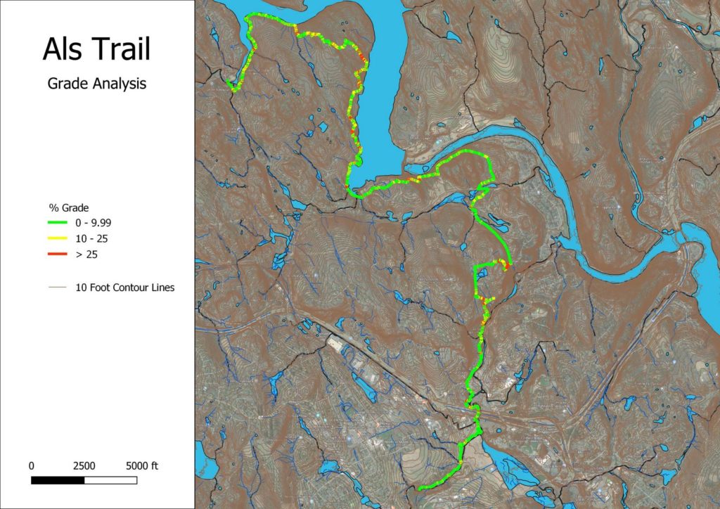
Using techniques within GIS, we can look at your entire trail – planned or existing, and see if there are any segments that seem unsustainable, and will create re-occuring maintenance issues in the future. This is an extremely valuable analysis, especially for planned trail networks before they go into the construction phase. It is much easier to make changes earlier in the process, saving potentially thousands of dollars as a result of poor planning.
2. Document Maintenance Needs
All trails need maintenance. Those built in a more sustainable way require less. By realizing that, budgeting for maintenance is a part of managing a trail system. Our trail assessment of your property will uncover areas that require attention and develop a maintenance plan that address those needs.
3. Uncover New Trail Opportunities
Sometimes having a second set of eyes can uncover things you may have missed – an opportunity to connect to another point of interest, a reroute that avoids a negative anchor point, finding unused land suitable for another trail, or simply changing that feature to make your trail more fun to ride! Whatever it may be, our trail assessment will help improve your trail system.
4. Our Trail Assessment Can Help Improve Safety on Your Multi-Use or MTB Trails
Our trail assessment can be geared towards improving safety on your trail. We can help identify problem areas that could create potential safety hazards for users. If you have bike trails with features on your property, or a bike bike, Planet Zero Gravity can provide aerial mapping services which can model the terrain and accompanying features in 3D. From this model, distance measurements and angles can be taken on a computer and compared with known best practices for mountain biking trail designs.